Difference between revisions of "New Delfos"
(→GEOGRAPHY) |
|||
| Line 4: | Line 4: | ||
| align="center" colspan="2"| | | align="center" colspan="2"| | ||
{| border=0 cellpadding=2 cellspacing=0 style="background:#f9f9f9; text-align:center;" | {| border=0 cellpadding=2 cellspacing=0 style="background:#f9f9f9; text-align:center;" | ||
| − | | width="130px"| | + | | width="130px"| [[File:ND_flag2014.png|100px]] || align=center width=130px| [[File:NDcoa.png|100px]] |
|- | |- | ||
| align=center colspan=2 | '''Flag and Coat of Arms of New Delfos''' | | align=center colspan=2 | '''Flag and Coat of Arms of New Delfos''' | ||
Latest revision as of 03:07, 15 March 2015
| |||||
| <motto> | |||||
| Map | <map> | ||||
| Official Language | <insert> | ||||
| Official Religion | <insert> | ||||
| Ethnicities | <insert> | ||||
| Capital | Delfingrado | ||||
| President of the Committee | x | ||||
| President of the Parliament | x | ||||
| Area | <amount> km2 | ||||
| Population - Total (February 2007) - Density |
<population>
<density>/km2 | ||||
| Independence | <date> | ||||
| Government Type | Democratic Council and Parliament of Regions | ||||
| Nation Type | Democratic Federation of States | ||||
| Economic System | Social Economy | ||||
| National Symbols | (Delphian) Big Red Tomato | ||||
| HDI | <insert> | ||||
| Currency | delf | ||||
| International Abbreviations - sport - government |
Delf, DEL, n-d | ||||
| Pronunciation | New DEL-phoos | ||||
| Naval Craft Classification | NDS | ||||
| National Anthem | <anthem> | ||||
| Internet TLD | .nd | ||||
| Calling Code | 356 | ||||
Contents
- 1 INTRODUCTION
- 2 GEOGRAPHY
- 3 PEOPLE
- 4 GOVERNMENT
- 4.1 Country Name
- 4.2 Government Type
- 4.3 Capitol
- 4.4 Administrative Divisions
- 4.5 Creation
- 4.6 National Holidays
- 4.7 CONSTITUTION
- 4.8 Anthem
- 4.9 Suffrage
- 4.10 Executive Branch
- 4.11 Legislative Branch
- 4.12 Judicial Branch
- 4.13 Political Parties
- 4.14 Political Pressure Groups
- 4.15 International Organization Participation
- 4.16 Flag Description
- 5 ECONOMY
- 6 COMMUNICATIONS
- 7 TRANSPORTATION
- 8 MILITARY
- 9 TRANSNATIONAL ISSUES
INTRODUCTION
GEOGRAPHY
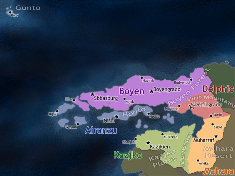
The geography of New Delfos consists mainly on Mainland Delfos, the Delphic Sea Islands and the Archipelago of Gunto.
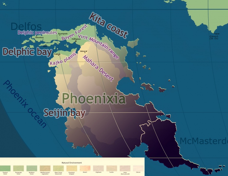
- Mainland Delfos: The land area that comprises New Delfos is often described as a crescent moon open to the west bathed by the Delphic Sea, also known as Delphic Bay.
- The Boyen Region is sometimes divided as Western and Eastern Boyen. It's Northern coast is aggressively tropical with the exception of a few bays and peninsulas.
- Western Boyen is known for it's fertile small hills, tropical forests, and large beaches.
- Eastern Boyen can be characterized mostly for the Boyen Forest that is the biggest and most dense forest in New Delfos, in the south the Boyen Forest kisses a mountainous range also known as Virit Line.
- The Delpho Region is a temperate forest and grassland region south of the Virit Line mountain-range. The terrain slowly turns into steppes in the South. The Delpho Region is also well known for it's rivers and natural fountains, although it's historic Delfos Fountain has long dried out, where deities would come from Illub.
- Mahara Desert lends it's name to the Mahara Region. The shores in Delphic Bay is fertile temperate grasslands but most of this region is desert and steppes. On the West the very high Jidhar Mountains abruptly separate Mahara from Kazjko with snowy tops.
- West of the Jidhar Mountains, the Kazjko Region is notorious for it's vast plains and very fertile temperate coast.
- The Boyen Region is sometimes divided as Western and Eastern Boyen. It's Northern coast is aggressively tropical with the exception of a few bays and peninsulas.
- The tropical islands of the Delphic Sea are part of the Airanzu Region. Honto is the main island in the middle of the Delphic Bay, it has temperate cool mountains and temperate grasslands around them.
- Northwest of Mainland Delfos, in the middle of the Phoenix Ocean, the small and tropical Archipelago of Gunto is a group of four islands which are also part of the Airanzu Region.
- The Eastern Group has three islands that are part of the same oceanic mountain-range: the main and biggest island of the archipelago is Pico and is also the easternmost characterized by a very tall mountain at it's center, followed by the islands of Flores and Terceira.
- The Western island is called Corvo (Crow), and is much further away from the other islands. It's a very old volcano with a large crater created by a plinian eruption roughly 500 thousand years ago.
Location
New Delfos is located on the Northwest part of the Phoenixia Continent.
Geographic Coordinates
Land Area
Area Comparative
Land Boundaries
Total:
Border Countries:
Coastline
Maritime Claims
territorial sea: File:Example.jpg
Climate
Terrain
Elevation Extremes
Lowest Point:
Highest Point:
Natural Resources
Natural Hazards
Environment-Current Issues
Environment-International Agreements
PEOPLE
Population
Age Structure
0-14 years:
15-64 years:
65 years and over:
Median Age
total:
male:
female:
Population Growth Rate
Infant Mortality Rate
Total:
Male:
Female:
Life Expectancy at Birth
total population:
male:
female:
Nationality
Noun:
Adjective:
Ethnic Groups
Religions
Languages
Literacy
Definition: age fifteen and over can read and write
Total Population:
GOVERNMENT
Country Name
Conventional Long Form:
Conventional Short Form:
Abbreviation:
Government Type
Capitol
Name:
Coordinates: N, W
Administrative Divisions
Creation
National Holidays
CONSTITUTION
Anthem
Suffrage
Executive Branch
Head of State:
Head of Government:
Cabinet:
Elections:
Legislative Branch
Judicial Branch
Political Parties
Political Pressure Groups
International Organization Participation
United Axis of Socialist States [[1]]
Flag Description
ECONOMY
Steadystate Tracker[2]
Economy Overview
Labor Force by Occupation
Exports-commodities
Exports-partners
Imports-commodities
Common
Rare
Imports-partners
Currency Code
Fiscal Year
COMMUNICATIONS
Telephones-main lines in use
Telephones-mobile cellular
Radio Broadcast Stations
AM , FM , shortwave
Television Broadcast Stations
Internet Country Code
Internet Hosts
Internet Users
TRANSPORTATION
Airports
Airports-with paved runways
total:
over 3,047 m:
2,438 to 3,047 m:
1,524 to 2,437 m:
914 to 1,523 m:
under 914 m:
Airports-with unpaved runways
total:
1,524 to 2,437 m:
914 to 1,523 m:
under 914 m:
Pipelines
gas km; oil km
Railways
total: km
standard gauge: km
maglev: km
note: maglev is planned to replace standard gauge entirely by 2050.
Roadways
total: km
paved: 5 km (including 638 km of expressway)
unpaved: km
Waterways
km
Merchant Marine
Total: ships
By Type:
bulk carrier
cargo
chemical tanker
passenger
petroleum tanker
refrigerated cargo


