Honto
| |||||
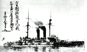
| Unsinkable Ship | |||||
| Map | | ||||
| Official Language | Nichibotsu (2nd)Delphic | ||||
| Ethnicities | 90% Seijin | ||||
| Capital | Nishi | ||||
| President of Honto and Airanzu Region | Ryo Kurokawa | ||||
| President of the Airanzu Parliament | Atsuhito Daigo | ||||
| Area | <amount> km2 | ||||
| Population - Total (February 2015) - Density |
50 Million 180/km2 | ||||
| Government Type | Parliamentary | ||||
| Nation Type | Democratic Republic (Federated) | ||||
| National Symbols | White Waves | ||||
| Currency | delf (Federal Currency) | ||||
| Pronunciation | Hon-toh | ||||
| Naval Craft Classification | HDS / NDS | ||||
| National Anthem | Sunset over blue | ||||
| Internet TLD | .hon | ||||
| Calling Code | 351 | ||||

Contents
[hide]History
Early History
Honto, the Main Island of the Delphic Bay has been populated since the establishment of the Indo-Phoenixian people and has always been regarded as a focal point of the Seijin ethnology in Phoenixia. Although Seijin Bay is regarded as the oldest settlement of the early Seijin in Phoenixia, excavations in Honto have revealed earthenware more than 10000 years old, predating the arrival of Suna-Khemish influences by at least 5 thousand years.
Honto is first mentioned in Delphic-Suna tablets dating 2000BC over trade and also suggesting that Honto was culturally dominated by Illidian Period of the early Mahara-Suna civilization.
(to be concluded)
Honto Empire

At second half of the 1800s, two centuries of civil wars and isolationist policies had forced many Seijin territories, known as Domeikuni (Allied Countries) to the Honto Feudalism system, to cut ties with Honto. The political differences between the Domeikuni and Honto had reached a limit, many former allies siding with the closer and extremely progressive Boyen Republic (the result of the Alliance of Delphic Free States). The young Empress Ichijo at the time decided, together with the inner council (later known as Restoration Council) and Ozian diplomats, to take over and reform Honto to Domeikuni, ending the Taikun rule of Fushimi and installing a modern government, taking part of the rising industrialization, sent their brightest to the Delphic Association of Craftsmen, and secured trade deals with Ozia, starting the Restoration Era of the Honto Empire.

The
(to be concluded)
GEOGRAPHY

- Honto is the "Main Island" of the Delphic Bay, it has temperate cool mountains and temperate grasslands around them.
Location
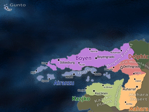
Honto is located in the middle of the Delphic Bay and is part of the Airanzu Region of New Delfos.
PEOPLE
Seijin (to be concluded)
Population
50 Million
Nationality
Noun:
Adjective:
Ethnic Groups
Seijin
Religions
Languages
Nichibotsu Delphic
GOVERNMENT
(to be concluded, explain how it integrates New Delfos)
Government Type
Parliamentary (to be concluded)
Capital
Name: Nishi
National Holidays
CONSTITUTION
Anthem
Sunset over Blue
Executive Branch
President of the Honto Government: Ryo Kurokawa (also representative of the Airanzu Region in the Council of Regions)
Cabinet: Minister Kawasaki (Environment, Territory and Energy)
Elections: every 4 years
Legislative Branch
President of the Airanzu Parliament: Atsuhito Daigo
Elections: every 4 years
Political Parties
(to be concluded)
Flag Description

White Waves is a light Cobalt Blue 3:4 flag with 4 wavy lines closely parallel to each other crossing the flag horizontally. The rapid association of the name, colors and shapes with sea is a modern construct from the 1800s, the so called "waves" is actually a signal borrowed from older iconographic representations of the Main Island's shape, mimicking a sea serpent which is linked to Honto's Creation Mythology. Linked to this Mythology, the Capital of Honto before the 1800s was actually in Heddo, the "Head" of the serpent.
ECONOMY
Economy Overview
Labor Force by Occupation
Exports
Imports
TRANSPORTATION
Airports
Railways
total: km
standard gauge: km
maglev: km
note: maglev is planned to replace standard gauge entirely by 2050.
Roadways
total: km
paved: 5 km (including 638 km of expressway)
unpaved: km